NUWARA ELIYA

Cool climate town shaped by tea estates and colonial charm.

Set in Sri Lanka’s central highlands, Nuwara Eliya is a well known hill town surrounded by rolling tea plantations, misty hills, and open valleys. Often referred to as Little England, the town blends colonial era architecture with working estate life, offering a cooler climate and a distinct atmosphere unlike anywhere else on the island.

Attractions

9 Top Picks | 6 Worth Seeing | 2 Optional

Scenery
Urban Park
Landscaped public park located beside Gregory Lake in central Nuwara Eliya.
Scenery
Scenery
Open lawns, lakeside views, surrounding hills, seasonal flowers, and cool highland weather.
Scenery
Activities
Walking, relaxing, photography, casual recreation, and boat riding.
Scenery
History
Developed during the British colonial period alongside Gregory Lake, named after Governor Sir William Gregory.
Map Icon
Location

MapLake & park
Gregory Park
Top Pick
Gregory Park is a landscaped public park located beside Gregory Lake in the heart of Nuwara Eliya, offering a broad open space within Sri Lanka’s most prominent hill town. Set against a backdrop of cool temperatures, misty mornings, and surrounding hills, the park provides a contrast to the dense town streets nearby. Its gently sloping lawns and lakeside position make it one of the most relaxed and accessible outdoor spaces in Nuwara Eliya.

The area around Gregory Park was shaped during the British colonial period, when the lake itself was expanded under the administration of Sir William Gregory, Governor of Ceylon in the late 19th century. The park and lake formed part of a broader effort to manage water resources while also creating recreational spaces inspired by English town planning. This colonial influence remains visible in the open layout, emphasis on leisure, and integration of natural scenery with human design.

Today, Gregory Park functions as both a recreational and social space. Locals use the park for casual walks, short breaks, and family outings, while visitors often come to enjoy the cool climate and lakeside views. The area around the park includes small activity zones, food stalls, and seating areas, creating a lively but unhurried atmosphere. Seasonal flowers, open lawns, and the reflective surface of the lake change character throughout the day, especially in the late afternoon when light softens and temperatures drop further.

For travellers exploring Nuwara Eliya, Gregory Park offers a pause between sightseeing stops. It allows visitors to experience the town’s climate, pace of life, and landscape without needing long travel or physical effort. Whether used as a brief stop or a longer rest, the park remains a central part of Nuwara Eliya’s identity as a cool-climate hill town shaped by both nature and history.
Read More
Scenery
Botanical Garden
Major highland botanical garden featuring temperate and subtropical plant species.
Scenery
Scenery
Manicured lawns, forested surroundings, flowering gardens, tall trees, and misty hill backdrops.
Scenery
History
Established in 1861 during the British colonial period, originally for cinchona cultivation and later expanded into a botanical garden.
Entrance Fee
Entrance Fee
LKR 3,300 ($11 USD ) Tickets near the cave

Map Ticket Counter

! Fees are approximate and can vary based on factors such as season, group size, and additional services.
Hakgala Botanical Garden
Top Pick
Hakgala Botanical Garden is one of Sri Lanka’s five major botanical gardens, located a short drive from Nuwara Eliya, at the base of Hakgala Rock. Set at a higher elevation than most gardens in the country, Hakgala is known for its cool climate, misty atmosphere, and carefully maintained landscapes. The garden spreads across gently sloping ground surrounded by forested hills, creating a quiet and enclosed setting distinct from the town centre.

The garden was established in 1861 during the British colonial period, initially as an experimental site for cultivating cinchona, the plant used to produce quinine. Over time, it was developed into a botanical garden focusing on temperate and subtropical plant species that thrive in cooler conditions. Hakgala’s location made it ideal for growing roses, conifers, ferns, orchids, and flowering plants not commonly found elsewhere in Sri Lanka. The layout reflects colonial era garden planning, with open lawns, winding paths, and themed plant sections.

Today, Hakgala Botanical Garden is valued both for scientific conservation and for quiet recreation. Visitors move through shaded pathways lined with tall trees, flower beds, and carefully curated plant collections, with views opening occasionally toward the surrounding hills. Seasonal changes strongly influence the garden’s appearance, with blooms peaking at different times of the year. Compared to busier urban parks, Hakgala offers a slower, more contemplative experience, suited to walking, photography, and observing plant diversity at leisure.

For travellers exploring Nuwara Eliya, Hakgala Botanical Garden provides a balance between natural landscape and structured design. It offers insight into Sri Lanka’s colonial botanical history while remaining a calm retreat from the town’s activity. The combination of elevation, climate, and curated greenery makes it one of the most distinctive green spaces in the central highlands.
Read More
Lake
Hindu Temple
Active Hindu temple dedicated to Seeta Devi, associated with Ramayana tradition.
Scenery
Scenery
Forested surroundings, flowing streams, cultivated land, and cool highland atmosphere near Hakgala.
Scenery
Art & Culture
Colourful South Indian style Hindu architecture, deity statues, and ongoing devotional practices linked to Ramayana belief.
Map Icon
Location

MapHindu Kovil
Seeta Amman Kovil
Top Pick
Seeta Amman Kovil is a Hindu temple located near Hakgala, a short distance from Nuwara Eliya, set within forested highland terrain and agricultural land. The temple is one of the most significant Ramayana tradition sites in Sri Lanka and is dedicated to Seeta Devi, wife of Lord Rama. Its location, surrounded by cool climate vegetation and flowing streams, gives it a quiet and contemplative atmosphere distinct from larger urban temples.

According to Ramayana tradition, this area is believed to be the place where Seeta was held captive by King Ravana, and where she prayed daily. Footprint-like impressions found on rock surfaces nearby are locally believed to belong to Lord Hanuman. While these associations are rooted in religious belief rather than archaeological evidence, they form an important part of the temple’s spiritual and cultural identity and attract devotees from Sri Lanka and India throughout the year.

The temple structure features brightly coloured South Indian Hindu architectural elements, including statues of deities, carved pillars, and decorative shrines. These vivid forms stand out against the muted greens of the surrounding hills. Religious rituals, prayers, and festivals continue to be actively observed, making Seeta Amman Kovil a living place of worship rather than a static heritage site.

For travellers visiting Nuwara Eliya, Seeta Amman Kovil offers insight into the island’s Hindu cultural landscape and the strong influence of Ramayana based tradition in the central highlands. The site adds cultural depth to the region, complementing nearby botanical gardens, viewpoints, and natural attractions with a spiritual narrative tied closely to place and belief.
Read More
Scenery
Buddhist Temple
Modern hilltop Buddhist temple known for its setting around a single prominent tree.
Scenery
Scenery
Elevated views of valleys, tea estates, distant hills, and open highland skies.
Scenery
Art & Culture
Modern Buddhist design focused on simplicity, meditation, and harmony with the natural environment.
Map Icon
Location

MapTemple
Swarnagiri Maha Viharaya
Top Pick
Swarnagiri Maha Viharaya, commonly known as the Single Tree Temple, is a Buddhist temple located near Nuwara Eliya, set on elevated ground overlooking the surrounding hill country. The temple is best known for being built around and beside a single, prominent tree, which has become both a visual symbol and a spiritual focal point of the site. Its position offers open views across valleys, tea estates, and distant hills, giving the temple a calm and spacious atmosphere.

The temple is a modern Buddhist establishment, developed in the late 20th century, rather than an ancient monastery. It was established as a place of worship, meditation, and quiet reflection, making use of the natural landscape rather than monumental architecture. The name Swarnagiri reflects the elevated rocky setting of the temple, while the popular name Single Tree Temple comes from the way the main structure and grounds are organised around the solitary tree that dominates the site.

Architecturally, Swarnagiri Maha Viharaya is simple and contemporary, with clean lines, open terraces, and minimal ornamentation. The emphasis is placed on views, silence, and connection with nature rather than elaborate decoration. The tree itself is treated with reverence, symbolising endurance, protection, and harmony between spiritual practice and the natural environment. For visitors, the setting feels more contemplative than ceremonial.

For travellers visiting Nuwara Eliya, the Single Tree Temple offers a quieter alternative to busier religious sites. It is well suited for short visits, meditation, and sunset viewing, allowing visitors to experience Buddhist practice in a modern hill country context shaped by landscape rather than crowds or ritual activity.
Read More
Scenery
Waterfall
Wide multi-stream waterfall formed by Horton Plains tributaries, one of the largest in Sri Lanka by width.
Scenery
Scenery
Dense forest, open grassland, rocky terrain, mist, and powerful flowing water.
Hike
Hike
Moderate walk through forest and open terrain to reach the waterfall. Uneven ground near the base.
Bomburu Ella Waterfall
Top Pick
Bomburu Ella Waterfall is one of Sri Lanka’s widest and most impressive waterfalls, located on the border of Nuwara Eliya and Badulla districts, near the village of Kalupahana. Rather than a single vertical drop, Bomburu Ella spreads across a broad rock face with multiple streams flowing side by side, creating a powerful and immersive scene. Its scale and setting make it feel wild and expansive compared to roadside waterfalls in the hill country.

The waterfall is fed by tributaries originating from the Horton Plains plateau, giving it a strong and consistent water supply, especially after rainfall. Reaching Bomburu Ella involves a walk through forested trails and open grassland, allowing visitors to experience the surrounding environment gradually before the falls come into view. The sound of rushing water grows louder as the path descends toward the basin, reinforcing the sense of arrival at a major natural feature.

At the base, the waterfall opens into a wide rocky area with flowing channels rather than a single plunge pool. Mist, wind, and sunlight interact constantly, changing the appearance of the falls throughout the day. The area feels raw and untamed, with minimal development and no formal viewing platforms. This lack of heavy infrastructure preserves the natural character of the site but also requires visitors to be cautious around slippery rocks and fast-moving water.

For travellers visiting Nuwara Eliya or moving toward Badulla, Bomburu Ella offers a more immersive outdoor experience than most easily accessible waterfalls. The combination of scale, surrounding forest, and physical approach makes it a destination in itself rather than a brief roadside stop, rewarding those willing to walk and explore the landscape at a slower pace.
Read More
Lake
Lake
Small highland reservoir supporting irrigation and water management near Bomburu Ella.
Scenery
Scenery
Still water, forested edges, open grassland, cultivated land, and misty highland surroundings.
Map Icon
Location

MapReservoir
Bomburuella Reservoir
Top Pick
Bomburuella Reservoir is a highland water body located near Bomburu Ella Waterfall, on the border of Nuwara Eliya and Badulla districts. Set within a landscape of forest, grassland, and cultivated land, the reservoir forms part of the upper catchment system that supports agriculture and water regulation in the surrounding hill country. Its setting feels quiet and rural, far removed from the busier town centres of Nuwara Eliya.

The reservoir was developed primarily for irrigation and local water management, collecting runoff from the surrounding highland terrain and Horton Plains tributaries. Unlike large hydroelectric reservoirs, Bomburuella Reservoir is modest in scale and closely tied to village life and farming activity. Its presence has shaped land use in the area, supporting paddy cultivation and small-scale agriculture downstream.

Visually, the reservoir blends gently into its surroundings, with still water reflecting forest edges, open sky, and nearby slopes. The atmosphere is calm, especially during early morning and late afternoon when mist settles low over the water. There are no major recreational facilities, and the area remains lightly developed, making it more suitable for quiet observation and photography rather than structured activity.

For travellers visiting Bomburu Ella Waterfall or exploring the eastern edge of the Nuwara Eliya highlands, Bomburuella Reservoir provides a subtle but grounding contrast to the dramatic movement of the falls. It highlights the relationship between highland water sources and everyday rural life, adding depth to the region’s natural story.
Read More
Scenery
Civic Building
Historic colonial-era post office still functioning as a public civic service in Nuwara Eliya.
Scenery
Scenery
Tudor Revival style with red brick walls, clock tower, steep roofs, and timber detailing. Set within the town centre, surrounded by colonial buildings and cool climate streetscapes.
Scenery
History
Built in 1894 during British rule as part of Nuwara Eliya’s development as a hill station.
Map Icon
Location

MapPost Office
Nuwara Eliya Post Office
Top Pick
The Nuwara Eliya Post Office is one of Sri Lanka’s most distinctive and well preserved colonial era buildings, located in the heart of Nuwara Eliya town. Instantly recognisable by its red brick façade, clock tower, and steeply pitched roof, the building stands out as a reminder of the town’s British heritage. Its design and setting reflect the transformation of Nuwara Eliya into a planned hill station during the colonial period.

The post office was constructed in 1894, during British rule, to serve the growing administrative and residential population of the hill country. Built in the Tudor Revival architectural style, the structure closely resembles English country buildings of the late 19th century. Unlike many colonial buildings that have been repurposed or altered, the Nuwara Eliya Post Office continues to function as an active postal facility, maintaining both its original purpose and architectural character.

Inside, the building retains much of its traditional layout, with wooden counters, high ceilings, and period details that add to its historic atmosphere. Visitors often stop here not only to post letters or postcards but also to appreciate the building itself as a living piece of colonial infrastructure. The surrounding streets, lined with other heritage buildings, reinforce the sense of stepping into a different era of Sri Lanka’s history.

For travellers exploring Nuwara Eliya, the post office offers more than a functional stop. It provides a tangible connection to the town’s colonial past while remaining part of everyday life. Sending a postcard from this historic building has become a small but meaningful ritual for visitors, linking travel memories with one of the country’s most iconic postal landmarks.
Read More
Scenery
Church
Historic Anglican church belonging to the Church of Ceylon, still in active use.
Scenery
History
Built in 1852 during British rule to serve colonial administrators and plantation communities in Nuwara Eliya.
Scenery
Scenery
Quiet church grounds set within the cool-climate townscape of Nuwara Eliya.
Scenery
Art & Culture
Gothic Revival style with stone construction, pointed arches, stained glass, and traditional church design.
Map Icon
Location

MapView on Map
Holy Trinity Church
Top Pick
Holy Trinity Church is one of the most prominent and historically significant Christian churches in Nuwara Eliya, located close to the town centre within the former British hill station area. Built to serve the Anglican community during the colonial period, the church reflects the strong influence of British settlement, administration, and plantation life in the central highlands. Its elevated position and spacious grounds give it a dignified presence within the town’s historic core.

The church was constructed in 1852, making it one of the oldest Anglican churches in Sri Lanka’s hill country. It was established during the early development of Nuwara Eliya as a retreat for British officials and planters seeking a cool climate. As part of the Church of Ceylon, Holy Trinity Church played a central role in religious life, social gatherings, and colonial-era ceremonies associated with the administration of the region.

Architecturally, Holy Trinity Church follows a Gothic Revival style, featuring pointed arches, tall windows, stone walls, and a traditional pitched roof. Inside, stained glass windows, timber fittings, and memorial plaques dedicated to British officials and planters reflect both religious devotion and colonial history. The surrounding churchyard and quiet setting add to the atmosphere of reflection and continuity, linking the present town to its 19th-century origins.

Today, Holy Trinity Church remains an active place of worship while also standing as an important heritage landmark in Nuwara Eliya. For visitors, it offers insight into the town’s colonial past and the role of Anglican institutions in shaping hill country life. The church complements nearby civic buildings, parks, and historic streets, forming part of the broader cultural landscape of Nuwara Eliya.
Read More
Scenery
Waterfall
Tall, narrow waterfall descending from the Nuwara Eliya plateau into a steep gorge.
Scenery
Scenery
Rocky cliffs, open highland views, distant valleys, and seasonal flowing water.
Hike
Hike
Reaching the top of the waterfall is very difficult and involves steep, uneven terrain.
Lover's Leap Waterfall
Worth It
Lover’s Leap Waterfall is a slender but striking waterfall located just outside Nuwara Eliya, near the edge of the town’s highland plateau. The waterfall drops from a rocky cliff into a narrow gorge below, creating a long vertical cascade rather than a wide flow. Its elevated position and proximity to town make it one of the more easily accessed natural features in the area.

The waterfall is fed by a small stream originating from the Horton Plains plateau, linking it hydrologically to the wider highland ecosystem. Water flow varies with seasonal rainfall, appearing more dramatic during wet periods and thinner during dry months. The surrounding terrain consists of rocky ground, low vegetation, and open highland views, reflecting the exposed nature of the plateau edge.

Lover’s Leap is closely associated with local legend, which tells the story of a forbidden romance that ended at the cliff edge near the falls. While the story belongs to folklore rather than recorded history, it has shaped the name and popular identity of the site. This blend of natural scenery and storytelling has made the waterfall a familiar stop for visitors exploring the outskirts of Nuwara Eliya.

The area around the waterfall is quiet and relatively undeveloped, allowing visitors to focus on the landscape itself. From nearby viewpoints, the land opens out toward distant valleys and plains, adding a sense of height and openness. For travellers in Nuwara Eliya, Lover’s Leap Waterfall offers a short and scenic stop that combines geology, water, and cultural narrative within easy reach of town.
Read More
Scenery
Botanical Garden
Public park located in the centre of Nuwara Eliya, offering landscaped green space and walking paths.
Scenery
Scenery
Manicured lawns, flower beds, tall trees, shaded paths, and cool highland surroundings.
Scenery
History
Established in 1897 to mark Queen Victoria’s Diamond Jubilee during British rule.
Entrance Fee
Entrance Fee
LKR 1,000 ($3 USD )

! Fees are approximate and can vary based on factors such as season, group size, and additional services.
Victoria Park
Worth It
Victoria Park is a centrally located public park in Nuwara Eliya, offering a calm green space within the town’s cool climate setting. Situated near the main commercial area and surrounded by colonial-era buildings, the park provides a quiet contrast to the busy streets nearby. Its well maintained lawns, walking paths, and shaded areas make it one of the most accessible outdoor spaces in the town.

The park was established in 1897 to commemorate the Diamond Jubilee of Queen Victoria, during the British colonial period. It was designed as a recreational garden in keeping with English park traditions, reflecting the transformation of Nuwara Eliya into a planned hill station. Over time, Victoria Park became an important civic space, serving both residents and visitors as a place for leisure and relaxation.

Victoria Park is also known for its botanical value, with a wide variety of plant species adapted to the highland climate. Flower beds, tall trees, and seasonal blooms give the park changing character throughout the year, particularly during spring when flowering plants are at their peak. Birdlife is another highlight, with several endemic and migratory species frequently seen within the park’s grounds.

For travellers exploring Nuwara Eliya, Victoria Park offers an easy stop to experience the town’s cooler climate and colonial-era planning in a relaxed setting. It is well suited for slow walks, short breaks, and quiet observation, making it a natural pause point between sightseeing stops across the town.
Read More
Lake
Lake
Small highland reservoir supporting local water storage and irrigation near Nuwara Eliya.
Scenery
Scenery
Still water, misty mornings, forest edges, grassland, and surrounding highland slopes.
Map Icon
Location

MapReservoir
Kande Ela Reservoir
Worth It
Kande Ela Reservoir is a small but scenic highland reservoir located near Nuwara Eliya, set within rolling hills, forest patches, and tea estate country. Positioned at a high elevation, the reservoir contributes to the cool and misty atmosphere that defines the region, often appearing calm and reflective during early mornings and late afternoons. Its surroundings feel quiet and lightly developed, reinforcing a strong sense of hill country calm.

The reservoir was constructed as part of local water storage and irrigation management, supporting agriculture and domestic water needs in the surrounding areas. Unlike large reservoirs built for hydroelectric power, Kande Ela Reservoir remains modest in scale and closely connected to village life and nearby estates. Its presence reflects how water has long been managed carefully in the central highlands to support cultivation and settlement.

Visually, the reservoir blends smoothly into the landscape, with still water bordered by grass, forest edges, and gently rising slopes. Mist frequently settles low over the water, softening the scenery and creating subtle shifts in colour and visibility throughout the day. The absence of heavy infrastructure allows the area to retain a natural and understated character, making it more suitable for observation than activity.

For visitors exploring Nuwara Eliya and nearby attractions such as Moon Plains or Pidurutalagala viewpoints, Kande Ela Reservoir offers a quiet pause away from busier sites. It highlights the relationship between highland water sources and everyday rural life, adding depth to the region’s natural and cultural landscape without demanding time or effort to experience.
Read More
Lake
Water Management Feature
Highland water diversion channel following natural terrain near Pattipola.
Scenery
Scenery
Open grassland, forest edges, misty conditions, and slow-flowing highland water.
Map Icon
Location

MapReservoir
Pattipola Natural Canal
Worth It
Pattipola Natural Canal is a historic water diversion channel located in the Pattipola area, near the upper reaches of the central highlands. The canal follows the natural contours of the land, guiding water gently across the plateau rather than forcing it through steep drops. Its alignment and construction reflect early knowledge of highland hydrology and the careful management of water in a challenging environment.

Unlike large reservoirs or formal irrigation tanks, the Pattipola Natural Canal functions as a gravity-fed channel, directing spring and stream water toward surrounding areas. The canal appears largely natural at first glance, but closer inspection reveals sections that were shaped or maintained to ensure consistent flow. This balance between natural formation and human intervention is typical of early highland water management systems, where minimal alteration achieved long-term stability.

The canal runs through open grassland and forest-edge terrain characteristic of the Pattipola plateau. Mist, wind, and cool temperatures shape the environment, and the slow-moving water often mirrors the surrounding sky and vegetation. The setting is quiet and understated, offering insight into how water was guided across high elevation landscapes without large-scale construction.

For visitors exploring Pattipola and nearby highland routes, the natural canal is best appreciated as a landscape feature with historical function rather than a visual landmark. It adds depth to the understanding of how people adapted to the plateau environment, linking water, terrain, and settlement patterns in Sri Lanka’s highest regions.
Read More
Lake
Agricultural Site
High altitude dairy farm set within open grasslands near Pattipola and Nuwara Eliya.
Scenery
Scenery
Wide grasslands, grazing cattle, misty conditions, and distant highland views.
Map Icon
Location

MapReservoir
Ambewela Dairy Farm
Worth It
Ambewela Farm is a well known highland dairy farm located near Pattipola and Nuwara Eliya, set within open grasslands at one of the highest elevations used for agriculture in Sri Lanka. Often referred to as Little New Zealand due to its wide pastures and cool climate, the farm stands out for its open landscape, grazing cattle, and distinctly non-tropical atmosphere. The surrounding terrain feels expansive and calm, shaped by wind, mist, and rolling grassland rather than dense forest or tea estates.

The farm was established during the colonial and post-independence period as part of efforts to develop large-scale dairy production suited to Sri Lanka’s cooler highland climate. Imported dairy cattle breeds were introduced, and the region’s natural grasslands were used to support milk production. Over time, Ambewela Farm became a key contributor to the country’s dairy industry and a reference point for highland agriculture.

Today, Ambewela Farm functions primarily as a working dairy facility, producing fresh milk and dairy products. Visitors often pass through the area to observe grazing cattle, farm operations, and the surrounding scenery rather than structured tourist activities. The absence of heavy development keeps the focus on landscape and agricultural life, with wide views stretching across grassland and distant hills under shifting weather conditions.

For travellers exploring Pattipola, Horton Plains routes, or the upper Nuwara Eliya region, Ambewela Farm offers a different perspective on the highlands. It highlights how elevation and climate shape not only natural ecosystems but also human activity, presenting a quieter and more grounded experience of hill country life beyond gardens, viewpoints, and waterfalls.
Read More
Scenery
Urban National Park
Urban national park protecting montane forest and grassland within Nuwara Eliya town.
Scenery
Scenery
Dense montane forest, bamboo patches, shaded trails, and cool highland atmosphere.
Scenery
Animals
Noted for birdlife, including several endemic and migratory species, along with small mammals and reptiles.
Entrance Fee
Entrance Fee
LKR 4,000 ($13 USD )

MapTicket Counter

! Fees are approximate and can vary based on factors such as season, group size, and additional services.
Map Icon
Location

MapNational Park
Galway’s Land National Park
Optional
Galway’s Land National Park is a compact but ecologically significant protected area located within Nuwara Eliya town, making it one of the few national parks in Sri Lanka situated inside an urban setting. Despite its small size, the park preserves a patch of montane forest and grassland, offering a rare glimpse into the natural ecosystem that once covered much of the central highlands before urban development.

The area was originally part of land used during the British colonial period and later declared a National Park in 2006 to protect its unique biodiversity. Its elevation, cool climate, and sheltered forest environment make it particularly important for birdlife. Galway’s Land is recognised as one of the best places in the hill country for birdwatching, with a high number of endemic and migratory species recorded within its boundaries.

Walking trails wind through dense forest, bamboo patches, and open clearings, creating a quiet and immersive experience despite the park’s proximity to town. The canopy cover keeps temperatures cool, and the absence of large crowds allows visitors to move slowly and observe wildlife in relative silence. Small mammals, reptiles, and butterflies can also be seen, though birds remain the main attraction.

For travellers visiting Nuwara Eliya, Galway’s Land National Park offers an easy and accessible nature experience without the need for long travel or strenuous hiking. It provides ecological context to the region, showing how highland forests function alongside human settlement, and adds depth to the town’s identity beyond its colonial architecture and parks.
Read More
Scenery
Plains / Grassland
High altitude open plains offering wide panoramic views of the central highlands.
Scenery
Scenery
Open grassland, distant mountain ranges, valleys, cloud movement, and expansive skies.
Hike
Hike / Trek
Entry by foot is not allowed. Visitors must use an authorised jeep to reach the plains and main viewpoint.
Entrance Fee
Entrance Fee
LKR 4,000 ($13 USD )

MapTicket Counter

! Fees are approximate and can vary based on factors such as season, group size, and additional services.
Moon Plains
Optional
Moon Plains is an elevated open grassland and viewpoint located near Nuwara Eliya, offering some of the widest panoramic views in Sri Lanka’s central highlands. The area sits above the surrounding valleys and forests, creating a broad, exposed landscape where the horizon feels unusually distant for the hill country. Its name reflects the open, almost barren character of the plains, especially under strong sunlight or misty conditions.

The plains are part of a high altitude ecosystem shaped by wind, grassland vegetation, and scattered forest patches. From the main viewpoint, visitors can see across layers of hills and valleys toward Pidurutalagala, Sri Lanka’s highest mountain, along with surrounding peaks and distant lowlands on clear days. Changing weather conditions play a major role in the experience, with visibility shifting rapidly between clear views and drifting cloud cover.

Access to Moon Plains is typically controlled, with visitors travelling by vehicle along a designated route before reaching the viewpoint. The area remains largely undeveloped, preserving its raw, open character. Unlike forested parks or botanical gardens, Moon Plains offers little shelter, emphasising exposure to wind, sky, and scale rather than intimacy or detail.

For travellers visiting Nuwara Eliya, Moon Plains provides a dramatic contrast to the town’s gardens and colonial streets. It highlights the vastness of the central highlands and offers a sense of elevation and openness that is difficult to find elsewhere nearby. Early mornings and late afternoons are especially valued for clearer views and softer light across the plains.
Read More
Scenery
Mountain
Sri Lanka’s highest peak, rising above the central highlands near Nuwara Eliya. 2,524 metres (8,281 feet) above sea level.
Scenery
Scenery
Montane forest, mist covered slopes, highland views, and distant valleys.
Hike
Access
Entry requires special permission as the area is military-protected. Hiking is not allowed. Access is limited to authorised vehicles only; bikes and tuk-tuks are not permitted.
Map Icon
Location

MapMountain
Pidurutalagala
Optional
Pidurutalagala, also known as Mount Pedro, is the highest mountain in Sri Lanka, rising to an elevation of 2,524 metres (8,281 feet) above sea level. Located just north of Nuwara Eliya, the mountain dominates the surrounding landscape and plays a key role in shaping the climate and water systems of the central highlands. Its upper slopes are often wrapped in mist, contributing to the cool temperatures experienced in the region.

The mountain is an important hydrological source, with numerous streams originating from its forested slopes and feeding major river systems. Dense montane forest covers much of the area, forming part of a sensitive high altitude ecosystem. Due to its ecological importance and strategic position, large sections of Pidurutalagala are protected, and public access to the summit is restricted.

A sealed road leads close to the top, passing through forest and open viewpoints along the way. However, the summit area itself is occupied by communication and military installations, which limits unrestricted access. Despite this, the lower viewpoints along the access road offer impressive views across Nuwara Eliya, surrounding valleys, and distant mountain ranges on clear days.

For visitors to Nuwara Eliya, Pidurutalagala is best experienced as a landscape presence rather than a hiking destination. Its scale, elevation, and influence on the surrounding environment are felt throughout the town and nearby attractions. Seen from Moon Plains or across the plateau, the mountain stands as a defining feature of Sri Lanka’s central highlands.
Read More
History
Wildlife
Sambar deer, rarely seen Sri Lankan leopards, endemic birds, purple-faced langurs, and other montane species adapted to cool climates.
Hike
Hike
Well-marked circular trail covering World’s End and Baker’s Falls. Moderate distance with exposed sections.
Scenery
Scenery
Open grasslands, cloud forest, cliffs, waterfalls, mist, and wide highland views.
Entrance Fee
Entrance Fee
Foreign (Non-SAARC): $25 adults $15 children Foreign (SAARC): $20 adults $10 children Under 6: Free

MapTicket Counter

! Fees are approximate and can vary based on factors such as season, group size, and additional services.
Map Icon
Location

MapView on Map
Horton Plains National Park
Top Pick
Horton Plains National Park is a high altitude protected area located in Sri Lanka’s central highlands, east of Nuwara Eliya, forming part of the island’s most important montane ecosystem. Sitting at elevations between 2,100 and 2,300 metres, the plateau is defined by open grasslands, cloud forest patches, and cool, often misty conditions. Its exposed terrain and wide horizons create a stark contrast to the surrounding forested slopes and tea country below.

The park is one of Sri Lanka’s most significant watershed areas, with several major rivers originating here, including tributaries of the Mahaweli, Kelani, and Walawe river systems. Horton Plains was designated a National Park in 1988 to protect its fragile ecosystem, endemic wildlife, and unique highland landscapes. It is also part of the Central Highlands UNESCO World Heritage Site, recognised for its outstanding biodiversity and ecological value.

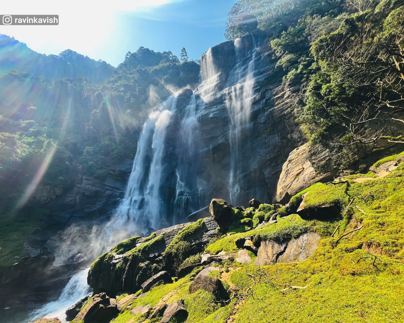
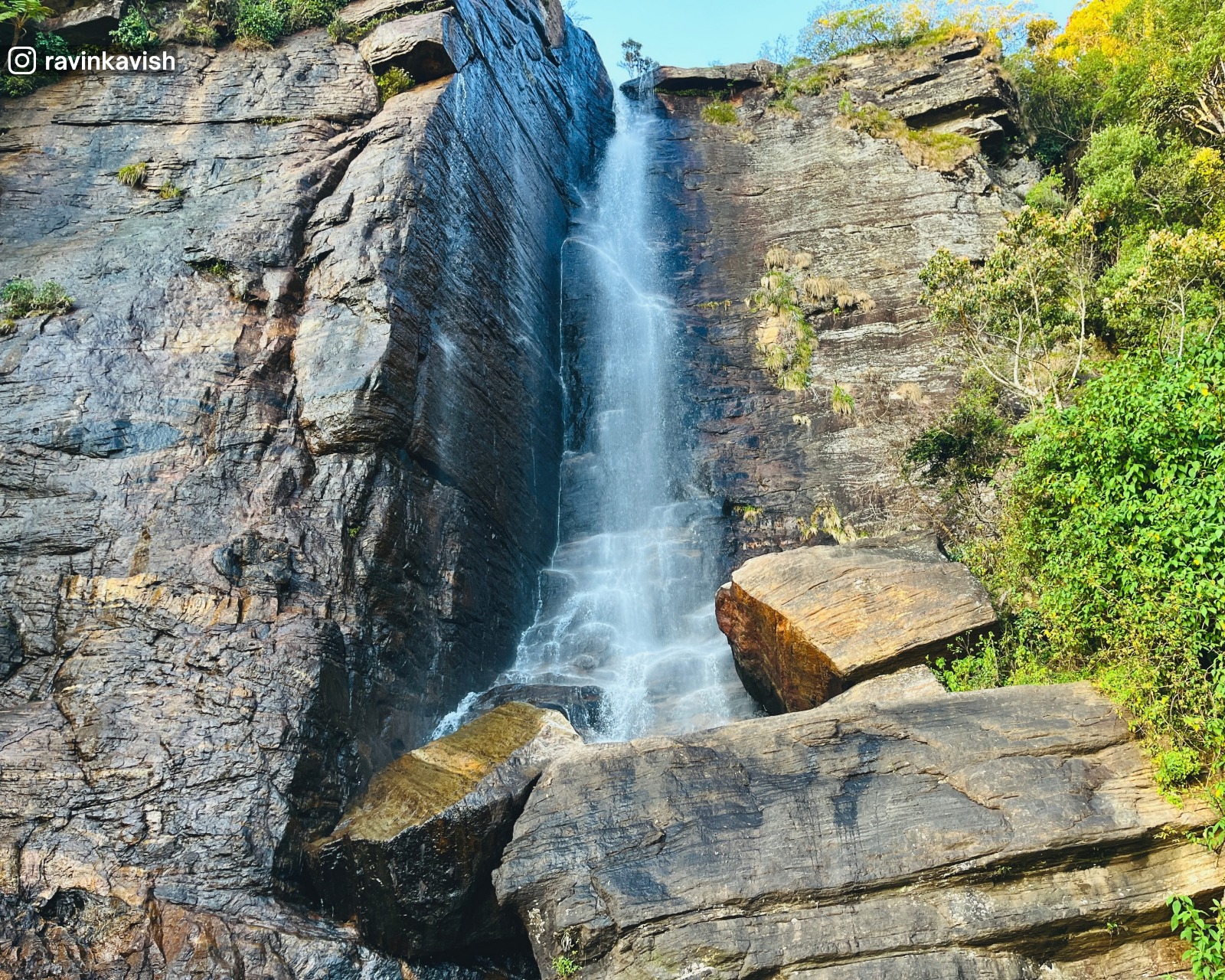
Horton Plains is best known for its dramatic natural features, including World’s End, a sheer cliff with a near-vertical drop of around 870 metres, and Baker’s Falls, a broad waterfall formed by the Belihul Oya. These landmarks are reached via a well-marked circular trail that passes through grasslands, forest sections, and exposed viewpoints. The walking experience is shaped by wind, cloud movement, and sudden changes in visibility, making each visit slightly different.

Wildlife in Horton Plains is subtle rather than abundant. The park is home to species such as sambar deer, purple-faced langurs, and a high number of endemic bird species adapted to montane conditions. Early mornings offer the best chance for wildlife sightings and clear views, before mist rolls in later in the day. Strict conservation rules limit access and activity to protect the sensitive environment.

For visitors, Horton Plains offers a focused and immersive experience centred on landscape, elevation, and ecological significance. It is not a casual park, but a place where weather, terrain, and distance shape the journey. For those exploring Nuwara Eliya and the surrounding highlands, the park represents one of the clearest expressions of Sri Lanka’s high altitude natural heritage.
Read More

Horton Plains National Park includes:

Scenery
Cliff Viewpoint
Sheer escarpment marking the edge of the Horton Plains plateau.
Scenery
Scenery
Sheer cliffs, distant lowland plains, layered hills, and shifting cloud cover.
Hike
Hike
Reached via the main Horton Plains circular trail through grassland and cloud forest.
Great World's End Drop
Top Pick
Great World’s End Drop is the most dramatic viewpoint within Horton Plains National Park, marking the edge of the central highland plateau where the land falls away into the lowlands below. From this point, the plateau ends abruptly at a sheer cliff with an almost vertical drop of approximately 870 metres (about 2,850 feet), creating one of the most striking natural features in Sri Lanka.

The cliff forms where the hard rock of the plateau gives way to steep escarpments shaped by long-term erosion. On clear mornings, the view extends far beyond the immediate drop, revealing layers of hills, valleys, and distant plains stretching toward the southern lowlands. Visibility is highly dependent on weather, as mist and cloud often roll in by mid-morning, obscuring the depth and scale of the landscape below.

Great World’s End is accessed via the main circular trail of Horton Plains, which passes through open grasslands and cloud forest before reaching the viewpoint. Unlike forested lookouts, the exposed nature of the cliff edge creates a strong sense of height and openness. Safety barriers are minimal, reinforcing the raw and unaltered character of the site while requiring visitors to exercise caution near the edge.

For visitors, Great World’s End Drop represents the defining moment of a Horton Plains walk. It captures the scale of Sri Lanka’s central highlands and the dramatic transition from cool plateau to warmer lowlands. When conditions are clear, the viewpoint offers one of the most memorable and expansive landscapes in the country.
Read More
Scenery
Waterfall
High altitude waterfall formed by the Belihul Oya within Horton Plains National Park.
Hike
Hike
Reached via the main Horton Plains circular trail with a short descent to the viewing area.
Scenery
Scenery
Wide cascading water, rocky terrain, cloud forest edges, and cool misty conditions.
Map Icon
Location

MapWaterfall
Baker’s Falls
Top Pick
Baker’s Falls is one of the most well known waterfalls within Horton Plains National Park, formed by the Belihul Oya, a tributary that originates in the central highlands. Unlike tall, narrow cascades, Baker’s Falls spreads across a broad rock face before dropping into a rocky pool below, giving it a wide and powerful appearance, especially after rainfall. The surrounding landscape of grassland and cloud forest frames the falls in a distinctly high altitude setting.

The waterfall is named after Sir Samuel Baker, a British explorer and big game hunter who played a role in exploring Sri Lanka’s highlands during the 19th century. While the naming reflects colonial influence, the falls themselves are part of a much older natural system shaped by erosion, water flow, and elevation over thousands of years. The cool climate and frequent mist add to the atmosphere, particularly in the early hours of the day.

Baker’s Falls is accessed via the main circular walking trail of Horton Plains, making it an integral part of the park’s hiking experience. A short side path leads down to a viewing area near the base of the falls, where visitors can observe the water as it moves over rock ledges and into the stream below. The terrain around the falls can be slippery due to spray and moss-covered rocks, requiring caution.

For visitors, Baker’s Falls provides a contrast to the dramatic cliff views of World’s End. It offers a closer, more grounded interaction with water and landscape, highlighting the role of the Horton Plains plateau as a vital watershed. Together with the surrounding grasslands and forests, the waterfall adds balance to the park’s overall experience by combining movement, sound, and texture within the highland environment.
Read More
Scenery
Mountain
Second highest mountain in Sri Lanka, located within Horton Plains National Park.
Hike
Hike
Long and demanding hike suitable for experienced hikers. Weather conditions can change rapidly.
Scenery
Scenery
Montane grasslands, cloud forest, exposed highland slopes, and wide plateau views.
Kirigalpoththa Mountain
Top Pick
Kirigalpoththa Mountain is the second highest peak in Sri Lanka, rising to an elevation of approximately 2,388 metres (7,835 feet) above sea level. Located within Horton Plains National Park, the mountain forms part of the central highland massif and is closely connected to the park’s montane grassland and cloud forest ecosystem. Its broad, forested slopes and exposed summit area give it a commanding presence within the plateau.

Unlike Pidurutalagala, Kirigalpoththa is accessible only on foot and remains fully protected within the national park. The trail to the summit passes through open grasslands, low shrubs, and sections of dense cloud forest, reflecting the changing vegetation zones of the highlands. Because of its elevation and exposure, weather conditions can change rapidly, with mist, wind, and cold temperatures shaping the experience.

Reaching the summit requires a long and physically demanding hike, making Kirigalpoththa one of the most challenging climbs available to the public in Sri Lanka. The route is less travelled than the main World’s End trail, adding to its remote and undisturbed character. From the upper slopes and summit, clear weather reveals wide views across the Horton Plains plateau and surrounding mountain ranges, emphasising the scale of the central highlands.

For experienced hikers visiting Horton Plains, Kirigalpoththa offers a deeper engagement with the park’s landscape beyond the standard viewpoints. It represents the quieter, more demanding side of the highlands, where effort and endurance are rewarded with isolation, altitude, and a strong sense of place within Sri Lanka’s highest terrain.
Read More
Scenery
Cliff Viewpoint
Secondary escarpment viewpoint marking the edge of the Horton Plains plateau.
Scenery
Scenery
Open grassland edge, steep descending slopes, distant hills, and drifting cloud cover.
Hike
Hike
Reached via the main Horton Plains circular trail. Moderate walking with exposed sections near the edge.
Mini World’s End
Top Pick
Mini World’s End is a cliff-edge viewpoint located within Horton Plains National Park, positioned along the main circular walking trail before reaching the Great World’s End. While smaller in scale, it clearly marks the edge of the highland plateau, where the land begins to drop away toward the valleys below. The viewpoint offers an early indication of the dramatic terrain that defines Horton Plains.

The drop at Mini World’s End is less extreme than the Great World’s End, but the exposed edge and open setting still create a strong sense of height. On clear mornings, the view opens across layered hills and descending slopes, with clouds often drifting below the plateau. Because it lies earlier along the trail, Mini World’s End is often visible even when mist later obscures the main drop.

Access to Mini World’s End is straightforward via the well-marked Horton Plains trail, passing through open grassland and patches of cloud forest. The surrounding area is quieter than the main viewpoint, allowing visitors to pause and take in the scenery without the intensity or crowding found at the Great World’s End. Weather conditions still change quickly, and the cliff edge remains exposed.

For visitors, Mini World’s End serves as a calm and informative stop rather than a headline attraction. It provides context to the plateau’s geography and prepares walkers for the scale of the landscape ahead, complementing the more dramatic Great World’s End rather than competing with it.
Read More